It wasn't until I was in the air that I remembered I didn't like flying.
Well that's not strictly true: the 'flying' bit, is in itself not too bad; it's the hurtling-back-down-to-earth-at-high-speed-in-order-to-land bit that I really don't like (especially when you are sat staring out of the window at a decidedly flimsy looking wheel that represents the only thing between you and a big hole in the runway tarmac).
Flying is a concept I've never been fully able to understand (aerodynamics not being a major component of my 'academic arsenal') although, to be fair, I've long since got past the urge to stand up mid-flight and scream about the inherent ridiculousness of being a mile above the surface of the earth in an unfeasibly heavy metal cylinder (although, to my shame, that did nearly happen once on a flight to Sicily some 20 years ago). This time I was only travelling between Southampton and Newcastle: just over an hour of flight. Not really enough time to read, eat or sleep. Plenty of time, however, to gaze out of the window down at the UK and repeat the mantra "stayintheair-stayintheair-stayintheair". After a while (12 minutes) this got a bit repetitive and, as we did in fact appear to be staying in the air, I dared to relax a little. Seeing that we were flying beneath the clouds, I began to take in the view.
Flying is a concept I've never been fully able to understand (aerodynamics not being a major component of my 'academic arsenal') although, to be fair, I've long since got past the urge to stand up mid-flight and scream about the inherent ridiculousness of being a mile above the surface of the earth in an unfeasibly heavy metal cylinder (although, to my shame, that did nearly happen once on a flight to Sicily some 20 years ago). This time I was only travelling between Southampton and Newcastle: just over an hour of flight. Not really enough time to read, eat or sleep. Plenty of time, however, to gaze out of the window down at the UK and repeat the mantra "stayintheair-stayintheair-stayintheair". After a while (12 minutes) this got a bit repetitive and, as we did in fact appear to be staying in the air, I dared to relax a little. Seeing that we were flying beneath the clouds, I began to take in the view.
Reading the landscape through close observation or analysing the detail on maps is one thing; looking down upon it at great height (and at high speed) is quite another. 'Topographic flattening' creates certain difficulties in interpretation, for, even if you are intimately familiar with a particular town or city on the ground, from the air the layout of streets and buildings can seem inordinately alien. Some structures are instantly recognisable from whatever height (the smoke-belching chimneys of Didcot coal and gas fired power station near Oxford - once voted Britain's worst eyesore - being a prime example);

Others are more tricky. Guess-the-historic-town-and/or-archaeological-monument, however, soon became both an absorbing game and an excellent way of taking my mind off the inherent ludicrousness of powered flight.

Others are more tricky. Guess-the-historic-town-and/or-archaeological-monument, however, soon became both an absorbing game and an excellent way of taking my mind off the inherent ludicrousness of powered flight.
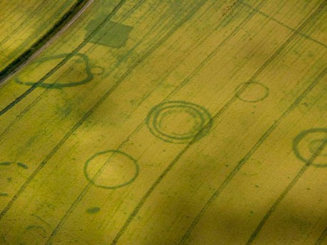
Soon I was happily spotting a whole range of landscape features. There was a ruined abbey, square courtyarded cloisters and church smashed down by Henry VIII's vandals; there was a Roman road, an arrow-straight line through the land still marked (like an unhealing scab) by hedgerows, farm tracks, B-roads and long-distance pathways. A motte-and-bailey castle stood close the centre of a small town, the winding grey streets that encircled it themselves surrounded by the redbrick and tile formality of 1980s suburbia. An ancient farm, rooms open to the sky, stood lonely and dejected at the side of a new urban bypass. Curious dark blotches, appearing bruise-like upon the surface of deeply ploughed fields, hinted at secrets beneath the soil; of buried field systems, barrows, enclosure ditches and long-forgotten storage pits.

I missed the overpriced sandwich trolley as it scuttled past, I missed the offer of having scalding hot tea poured lovingly on my leg and I even missed the announcement that we were finally nearing Newcastle. The sudden, stomach-churning lurch downwards towards a rapidly approaching thin linear stretch of grey tarmac brought me back into the real world. We were landing.
Very fast.
If I am ever required to fly again, I have my default setting of 'abject-terror-reduction': it's called aerial archaeology and it's quite simply wonderful.
If only it could be conducted on the ground.
No comments:
Post a Comment